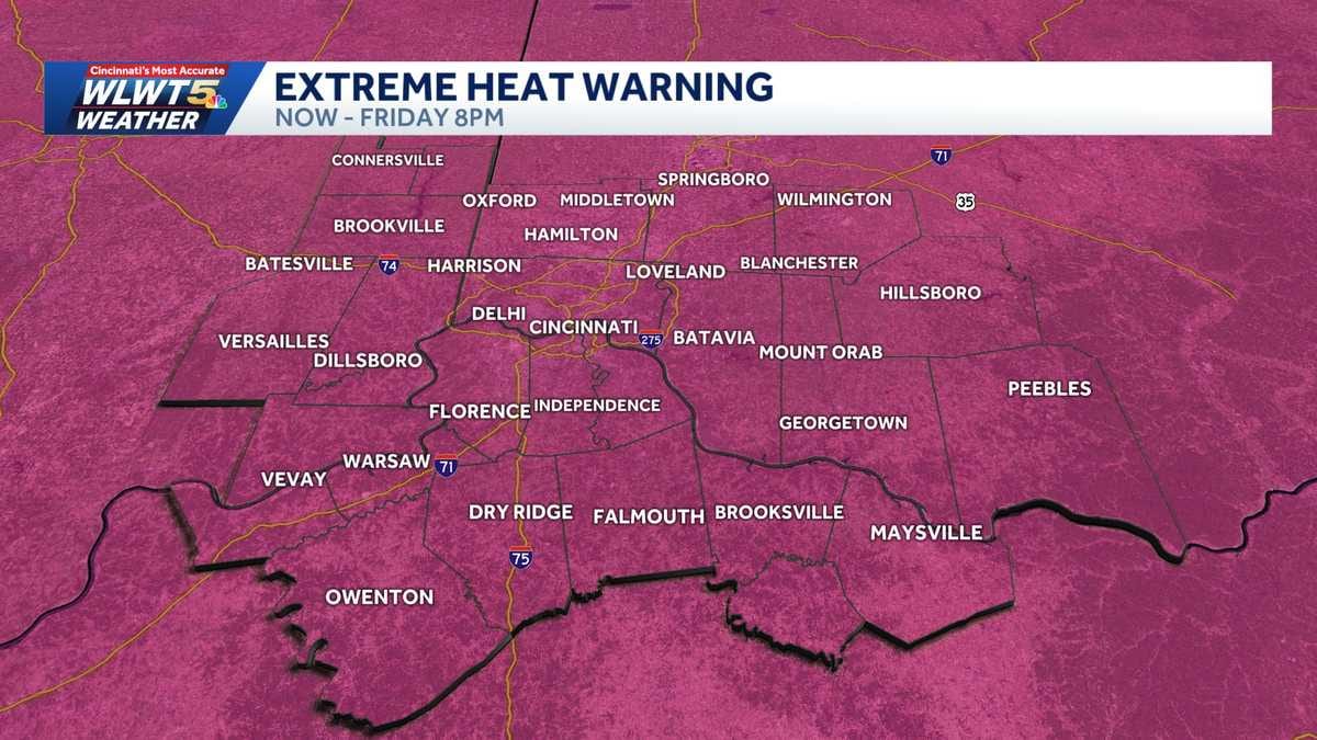
WLWT is warning of more intense heat heading into the 4th of July stretch, with Thursday highs around 92 and afternoon feels-like readings near 102. The alert comes as holiday travelers and event organizers lock in outdoor plans that could collide with both dangerous heat and incoming rain.
The station, reporting on July 2, says the worst of the heat will peak before showers and storms roll in over the weekend, setting up a tricky forecast for anyone banking on long hours outside. The mix of extreme heat, high humidity and changing conditions is already reshaping how people in the region are being told to prepare for the holiday.
Key facts
- Source
- WLWT
- Reported
- July 2, 2026
- Desk
- general
- Follow the story
- Spinn Radio Talk
How hot it will feel on Thursday, according to WLWT
WLWT projects Thursday afternoon temperatures near 92 degrees, with humidity pushing the heat index, or "feels-like" reading, to about 102. That is firmly in extreme heat territory, where prolonged time outside can quickly lead to heat exhaustion or heat stroke, especially for people working, exercising or celebrating without shade or cooling breaks.
The difference between the air temperature and the feels-like number matters. A reading around 92 might sound borderline manageable for some outdoor plans, but once it feels closer to 102, the body struggles to cool itself, particularly on concrete, in parking lots or near grills and fireworks setups. WLWT's forecast signals a need to rethink how long you stay out, and how often you hydrate and cool off on Thursday.
For anyone organizing early 4th of July events, that 102 feels-like figure is the key takeaway. It is a clear sign that mid-afternoon windows will be the most hazardous for parades, cookouts and sports, especially for children, older adults and anyone with health issues.
“A high near 92 might sound warm; a feels-like near 102 is a different level of risk.”
Why the extreme heat is peaking before 4th of July rain
WLWT frames Thursday as the most intense heat day before a shift toward wetter, stormier conditions that will influence the 4th of July weekend. That timing means the region gets a brief but dangerous heat spike, then trades some of that oppressive feel for the complications of rain and possible thunderstorms.
Heat building ahead of a wetter pattern is a common setup in early July. The atmosphere loads up with warmth and moisture, which sends heat index values higher, then releases it through showers and storms that can disrupt travel, fireworks and outdoor music or sports events. WLWT's warning that the heat ramps up, then gives way to rain, is a signal that conditions will be in flux from one day to the next.
For people planning backyard fireworks or outdoor concerts, that sequence matters more than the exact temperature number. It suggests Thursday is the day to be most careful about heat stress, while later in the weekend becomes a question of whether events can go ahead at all once showers and storms move in.
“The holiday forecast is not just hot or wet; it is hot first, then potentially stormy when plans peak.”
Spinn Radio
Follow live news on Spinn Radio
What this heat warning means for your July 4th plans
A feels-like temperature around 102 on Thursday changes how safe it is to stack long hours outside before the 4th. Even if your main celebration falls later in the weekend, WLWT's reporting suggests many people will start the holiday early, running errands, traveling, or setting up tents, stages and grills during the hottest hours.
The practical takeaway is timing and pacing. Morning and late evening windows are likely to be far safer for setup and travel than the mid-afternoon. Hydration, shade and regular breaks become more than comfort tips; they are part of managing a day flagged for extreme heat. If your plans include kids sports, extended tailgates or neighborhood block parties, consider adjusting schedules so the most active periods avoid the peak heat.
Once the rain and possible storms arrive, the risk shifts from heat illness to slippery roads, lightning and event cancellations. Keeping an eye on updates from local outlets like WLWT, plus live talk coverage on services such as Follow live news and talk on Spinn Radio, will be key as organizers weigh go or no-go calls through the weekend.
“Thursday is the day to front-load prep and slow down, so you are not fighting 102-degree heat index at the worst possible time.”
Who is most at risk in this early-summer heat spike
WLWT's projection of a 102 feels-like temperature highlights groups that are especially vulnerable. Older adults, young children, outdoor workers and people without reliable access to air conditioning face the highest risk when the humidity pushes conditions into extreme heat territory.
Even healthy adults can run into trouble on a day like this if they combine heavy physical activity, sun exposure and limited water breaks. The holiday context adds another layer, since alcohol intake and crowded events around grills and fireworks can mask early warning signs of heat-related illness. Looking out for friends, family and neighbors who might not have cooling options becomes part of how communities ride out a short but intense heat wave.
Pets and animals also feel the strain of a 102 heat index more quickly on hot pavement and in parked cars, even if the air temperature reads in the low 90s. WLWT's signal that Thursday is a standout heat day is a reminder to shorten walks, avoid locked vehicles and treat shade and water as essentials for animals too.
How to track the changing July 4th forecast
Because WLWT's reporting points to extreme heat followed by rain that could affect the 4th of July weekend, the forecast is not a set-it-and-forget-it situation. Conditions can shift as storms organize, which means timing and intensity might change in the hours leading up to parades, barbecues and fireworks shows.
The best strategy is to treat Thursday as the locked-in heat concern, then check for updated outlooks on holiday morning and again before major events. Local TV and radio forecasts, along with live news talk streams such as Follow live news and talk on Spinn Radio, will help flag any last-minute changes in storm timing or severe weather risk.
For now, the clear message is this: prepare for serious heat first, then stay flexible for a potentially soggy, storm-interrupted 4th of July. Keeping weather alerts on and building backup indoor options into your plans will make it easier to pivot if the rain arrives right when celebrations are supposed to begin.
“Treat Thursday's heat as a sure thing, and the holiday storms as a wildcard that demands backup plans.”
Good to know
Frequently asked questions
What is WLWT forecasting for Thursday’s heat?
WLWT is forecasting Thursday highs around 92 degrees with a feels-like temperature near 102 in the afternoon. That combination qualifies as extreme heat and calls for extra caution outdoors.
How will the holiday weekend weather change after the heat?
The heat is expected to peak Thursday before rain moves in over the 4th of July weekend. That shift trades oppressive heat for showers and possible storms that could affect outdoor plans.
Why is the early July heat dangerous for 4th of July events?
The early July heat is dangerous because a 102 heat index increases the risk of heat illness during long outdoor activities. Holiday crowds, alcohol and long setup times can make that risk easier to overlook.
How can I keep up with updates on the changing forecast?
You can keep up with updates by following local outlets like WLWT and tuning into live news talk on platforms such as Spinn Radio. Frequent checks are important as storm timing around the holiday can shift.
Explore more on Spinn Radio: Follow live news and talk on Spinn Radio
Sources