Newsweek is reporting that fast‑growing Canadian wildfires are now driving smoke across the border into the United States, with a new map showing millions of Americans in the path of unhealthy air. The report, published August 9, highlights how rapidly shifting plumes are turning a Canadian emergency into a cross‑border public‑health threat.
The fires have already forced mass evacuations inside Canada, and the smoke they generate is now degrading air quality across large parts of the U.S., from major cities to smaller communities. For people on the ground, this is no longer a distant blaze, it is a day‑to‑day question of what is safe to breathe and how long it will last.
Key facts
- Source
- Newsweek
- Reported
- August 9, 2026
- Desk
- general
- Follow the story
- Spinn Radio Talk
Where Newsweek’s wildfire smoke map shows the highest U.S. risk
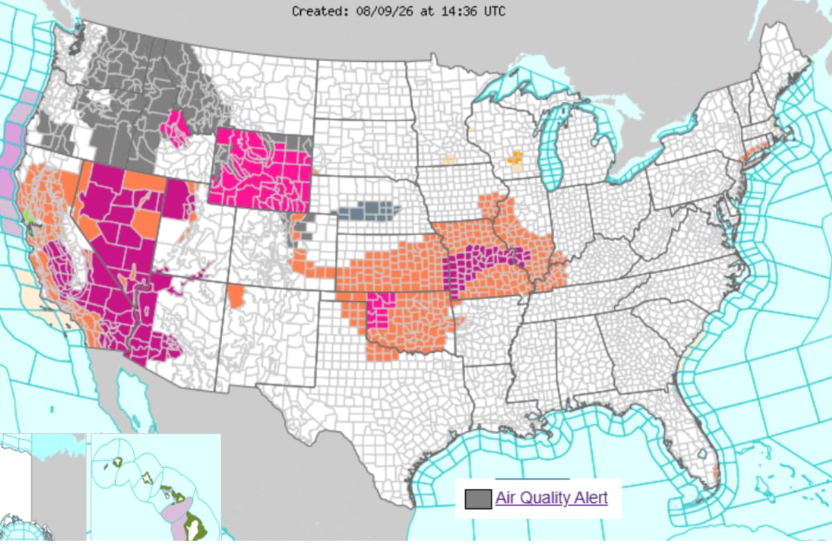
The core of Newsweek’s latest reporting is a map that tracks where smoke from Canadian wildfires is thickest as it drifts into the United States. The visual lays out bands of poor to hazardous air quality, making clear that the impact is not confined to towns near the border but stretches into heavily populated American regions where millions live and work.
The map matters because it translates a sprawling fire crisis into a simple question for readers: is my area in the smoke zone today. As the fires intensify, these shaded risk areas are expanding and shifting, which means communities that were in the clear yesterday may find themselves under a haze tomorrow. That basic takeaway, visible at a glance, is what turns a regional wildfire story into a national health concern.
Public agencies will use similar modeling to issue air‑quality alerts and health advisories. For residents, seeing their own city or county within a highlighted zone on the map is often the moment this story feels personal and urgent.
“The map turns a distant wildfire crisis into a simple question: is my area in the smoke zone today?”
How Canadian wildfires are forcing evacuations and spreading smoke
According to Newsweek, the fires inside Canada themselves are already severe enough to trigger mass evacuations. That means whole communities have been told to leave with little notice as flames threaten homes, infrastructure, and escape routes, even before smoke becomes an issue further south.
Those same fires are sending towering smoke columns into the atmosphere, where wind patterns carry the particles over long distances. Once in the upper air, that smoke does not respect borders, it is pushed into the United States and settles over cities and rural areas alike, reducing visibility and driving air quality to unhealthy levels.
For Americans watching from afar, the key connection is that every evacuation order in Canada often foreshadows days or weeks of degraded air further downwind. The underlying fires are the root of the problem, and any major new outbreak or shift in wind can quickly redraw the map of who is breathing the worst air.
Spinn Radio
Follow live news on Spinn Radio
Why wildfire smoke threatens health even far from the flames
Newsweek’s framing of “millions at risk” centers on air quality rather than direct fire danger. Smoke from large wildfires carries fine particles that can penetrate deep into the lungs, and when these particles build up over cities, the air can become hazardous even for people nowhere near the fire line.
Public‑health officials typically worry first about those with asthma, heart or lung disease, older adults, children, and people who work outside. When a map shows wide zones of poor air spreading across several U.S. states, it signals that vulnerable groups in many different communities may face the same set of cautions: limit strenuous outdoor activity, keep windows closed, and follow local alerts.
Even people who consider themselves healthy can feel the impact when smoke concentrations spike: eye irritation, coughing, or a scratchy throat are often the first signs that the air has shifted. The practical takeaway is simple. If your city appears under the smoke plume on a tool like the Newsweek map, treat that as a prompt to check current air‑quality readings and local guidance before planning long periods outside.
“When the map shows your city under the plume, that is the moment to check air quality before you head outside.”
What to watch as the Canadian fires and smoke risk evolve
Because Newsweek describes the wildfires as having “exploded, ” the situation should be treated as highly dynamic. Fire behavior can change quickly with wind, heat, and lightning, which means both the footprint of the flames and the path of the smoke will keep shifting over the coming days.
For Americans, the next key developments will likely include new or extended air‑quality alerts, more detailed maps that show hour‑by‑hour projections, and possible school or event disruptions in areas hit hardest by the smoke. Each new wave of evacuations in Canada, reported by outlets like Newsweek, is also a signal that smoke output could increase again and spread further into U.S. airspace.
If you live in an affected region, the most practical move is to follow trusted news sources and local officials who can interpret the latest maps and forecasts for your area. You can also keep an ear on how this story unfolds by tuning into live discussion and breaking updates on Follow live news and talk on Spinn Radio, which tracks developments as they shift.
How Americans can track the smoke and stay informed
Newsweek’s use of a map underscores how visual tools have become central to understanding climate‑driven disasters. For anyone in the U.S. wondering about current risk, the basic routine is to pair a reliable smoke or air‑quality map with local forecasts and alerts from city, state, or federal agencies.
Checking those resources daily while the Canadian fires keep burning can help you decide when to limit time outdoors, whether to adjust commuting or exercise plans, and when to pay extra attention to vulnerable family members or neighbors. When maps show conditions improving, that is also a signal that smoke has thinned and everyday activities may be safer to resume.
For broader context and ongoing analysis, platforms like Spinn Radio are tracking how this cross‑border fire season is affecting health, politics, and daily life. As Newsweek and other outlets update their reporting, the picture of where “millions at risk” are located will keep changing, and staying informed will matter as much as any mask or air filter.
Good to know
Frequently asked questions
What is happening with the Canadian wildfires right now?
Canadian wildfires have intensified enough to trigger mass evacuations, according to Newsweek. The scale of the burning is large enough that the impact now extends well beyond the immediate fire zones.
How are the fires affecting air quality in the United States?
Smoke from the Canadian fires is drifting into the U.S. and causing poor air quality for millions of Americans. Newsweek highlights a map showing wide areas where conditions have become unhealthy.
Which Americans are most at risk from the wildfire smoke?
Millions of Americans under the smoke plumes face elevated health risks, especially people with respiratory or heart conditions. Children, older adults, and outdoor workers are also more vulnerable when air quality drops.
How can people track where the wildfire smoke is going?
People can follow maps like the one highlighted by Newsweek that show where smoke and poor air quality are spreading. Paired with local alerts, those tools help residents see when their own area falls under a higher‑risk zone.
Explore more on Spinn Radio: Follow live news and talk on Spinn Radio
Sources