A heat wave gripping Europe is driving temperatures toward 39 and 40 degrees Celsius this week, prompting fresh weather alerts and warnings of disruption, according to DW.com. Authorities across the continent say a persistent “heat dome” pattern is locking hot air in place and raising the risk of dangerous conditions for residents and infrastructure.
The DW.com report, published June 21, sets out a twin threat: extreme heat affecting large parts of Europe and the prospect of intense thunderstorms in Germany. Officials are urging people to prepare for both the immediate health impacts and the knock-on effects on daily life.
Key facts
- Source
- DW.com
- Reported
- June 22, 2026
- Desk
- world
- Follow the story
- Spinn Radio Talk
How the European heat dome is driving temperatures toward 40°C
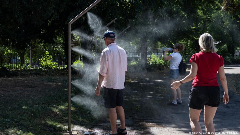
Meteorological agencies quoted by DW.com describe a heat dome pushing temperatures in parts of Europe toward and beyond 39 and 40 degrees Celsius. Under this pattern, a stable high-pressure system effectively caps the atmosphere, trapping hot air near the surface and allowing heat to build day after day.
The concern for forecasters is that a heat dome can turn what might have been a short heat spike into a prolonged heat wave. That raises the chance of record-breaking daytime highs as well as very warm nights, when people and infrastructure have little chance to cool down. Even without precise local readings, the simple threshold of “around 40 degrees” is a red flag: public health agencies in Europe typically treat temperatures in that range as dangerous, especially for older people, young children and anyone working outdoors.
For listeners and readers, the practical takeaway is straightforward. If you live in or are traveling through affected areas, expect outdoor activity to feel extreme, especially in the afternoon and early evening. Plan for shade, hydration and limited exertion during the hottest part of the day, and keep an eye on official advisories from local weather services.
“The phrase “around 40 degrees” is not just a number, it is the line where European authorities start talking about real danger, not just discomfort.”
Which parts of Europe are on alert and what disruptions to expect
DW.com reports that authorities across Europe have issued warnings as this heat wave develops, although specific countries and cities are not listed. That continent-wide language signals that the issue is not confined to one Mediterranean hot spot or a single capital. Instead, national weather services are likely escalating tiered alert systems that can include health advisories, transport warnings and, in some regions, early fire risk notices.
When temperatures push close to 40 degrees Celsius, rail infrastructure can be affected, as tracks expand under heat, and road surfaces may soften, which can slow traffic or force temporary limits. Urban centers can experience a pronounced heat island effect, making public transport, offices and apartments far warmer than the official air temperature suggests. Schools, outdoor events and workplace schedules can be adjusted or curtailed as authorities try to reduce exposure during peak heat.
For anyone moving around Europe in the coming days, the key detail is to build in flexibility. Heat alerts can mean slower journeys, rescheduled events and a higher likelihood of sudden changes in advice. Checking local transport operators and municipal updates before you set out will matter more than usual while the heat dome persists.
Spinn Radio
Follow live news on Spinn Radio
Why Germany faces an added threat of extreme thunderstorms
Alongside blistering heat, Germany is staring at another risk highlighted by DW.com: the potential for extreme thunderstorms. When intense heat builds, especially under a pattern like a heat dome, it stores a huge amount of energy in the lower atmosphere. If conditions shift just enough, that energy can be released in the form of violent storms.
The report does not detail precise storm tracks or expected damage in Germany, so the focus remains on the general warning. Extreme thunderstorms can bring heavy rain, powerful gusts of wind and rapid temperature drops, often in a short window. That combination can trigger flash flooding in urban areas, disrupt flights and rail services, and bring localized power outages. For Germany, this means residents in hot regions also need to be ready for fast-changing conditions later in the day.
The practical takeaway here is preparedness for swings rather than a single, stable pattern. If you are in Germany under this heat wave, conditions may shift from stifling heat to severe thunderstorms in a matter of hours, so both heat safety and storm safety advice from local authorities deserve close attention.
“Germany is not only sweating through a heat wave, it is also sitting under a loaded sky that could fire off extreme thunderstorms with little warning.”
Health and infrastructure risks as temperatures stay high
The DW.com reporting underlines what European health and civil protection agencies have stressed for years: temperatures near 40 degrees Celsius are a public health issue. Prolonged heat can exacerbate cardiovascular and respiratory conditions, put extra strain on hospitals and care homes, and sharply increase the risk of dehydration and heatstroke in the general population.
Infrastructure also comes under pressure in a sustained heat wave. Electricity grids can see surging demand as air conditioning and refrigeration units work harder, while water systems face increased use as people drink and shower more to cope. Public spaces that usually provide relief, such as parks and shaded squares, can become crowded, and buildings without modern cooling systems can quickly become unsafe for vulnerable residents.
For households, the most useful step is to treat the coming days as a period of elevated risk rather than a normal warm spell. That means checking on neighbors who may struggle, planning cooler indoor spaces if possible, and following basic precautions like staying hydrated and avoiding intense exercise during the hottest hours of the day.
What to watch next and how to stay informed on Spinn Radio
With the heat dome still in place, the central question over the next several days is whether temperatures keep climbing toward or beyond 40 degrees Celsius, or whether a change in the weather pattern brings some relief. DW.com’s coverage highlights that this is a developing situation, especially in Germany where severe thunderstorms could break parts of the heat while introducing fresh hazards.
Listeners following this story should watch for any escalation of alerts from national meteorological offices, as these often trigger additional public measures. That can include expanded opening hours for cooling centers, advice for employers on outdoor work, or restrictions on certain types of transport if conditions deteriorate. It is also worth tracking how different European countries respond, since policies on heat alerts and storm preparedness vary and can shape your experience on the ground.
To stay across the latest developments, you can Follow live news and talk on Spinn Radio, where rolling updates and expert voices will continue to track the heat wave, the thunderstorm risk in Germany and any broader disruption that emerges across Europe.
“The story of this heat wave is still being written: the same high-pressure dome that is baking Europe today could set the stage for sudden, violent storms tomorrow.”
Good to know
Frequently asked questions
What is causing the current European heat wave?
The current heat wave is being driven by a “heat dome” pattern over Europe that traps hot air and pushes temperatures toward 39 and 40 degrees Celsius. This stable high-pressure system keeps heat locked in place for days at a time.
How hot are temperatures expected to get in the heat wave?
Authorities have warned of temperatures exceeding 39 and 40 degrees Celsius in parts of Europe. That range is treated by public health agencies as dangerous, not just uncomfortable, especially for vulnerable people.
Why is Germany being warned about extreme thunderstorms?
Germany faces a threat of extreme thunderstorms linked to the same conditions fueling the heat wave. Intense heat can load the atmosphere with energy that is later released in violent storms with heavy rain and strong winds.
What should residents and travelers do during this heat wave?
Residents and travelers should monitor official weather alerts, avoid intense outdoor activity during peak heat, and prepare for possible disruption to transport and events. In Germany and nearby regions, it is also wise to be ready for sudden severe thunderstorms alongside the high temperatures.
Explore more on Spinn Radio: Follow live news and talk on Spinn Radio
Sources